More features for latest version of Skippy Scout drone app
A new version of Drone Ag’s Skippy Scout platform will allow users to take a complete aerial image of every field and view extra stats such as plants/sq m.
Skippy Scout was first introduced in March 2020 for growers and agronomists to conduct regular checks of specific field points as an aid to crop walking.
The app can run with any off-the-shelf drone, and extra functionality was added in October last year when Flight 2.0 was launched.
See also: How farmers can stay legal when flying a drone
The updated software of Flight 3.0 allows the whole field to be modelled in 3D and has power line detection, so instead of flying up to a set height before whizzing between points, the drone can now operate closer to the ground to help speed up the process and reduce battery use.

© MAG/Edd Mowbray
Bird’s-eye view
The system can also now stitch together panoramic pictures of the field, which are overlaid on the map when the scouting report is generated. Users can then zoom in on areas of concern for a more detailed look.
Drone Ag has responded to criticisms of the previous platform’s limitations by making it possible to view plants/sq m counts in freshly drilled crops.
The pictures can be translated into plant counts on images with 15% coverage on broad-leaved crops and 10% on cereals, making it easier to spot slower-emerging areas or those suffering from pest or disease pressures. There is potential for satellite data and yield maps to be included, too.
Existing users, of which there are now more than 100 (80% of whom are based in the UK), will get these extra features as part of their current packages.
Base station
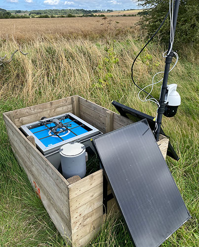
Future developments include a base station for the drone in the field, allowing it to charge, fly on its repeatable path, and return to the same point without any human intervention.
As it stands, users must bring the drone to the field for it to carry out an autonomous flight each time.
The new system sees the drone housed in a weatherproof box where it is charged automatically, using solar panels to keep the batteries topped up. However, the biggest hurdle to overcome is the current legislation restricting unmanned drone flights. There appears to be little likelihood of this law being relaxed in the short term, which means it would still require someone to monitor the flight remotely.
With that in mind, the £15,000 system, which is expected to be available next year, is more likely to find favour with large-scale farmers overseas.

