How to get started with a drone to monitor crops

© Gary Naylor
Drone technology has advanced dramatically in recent years, becoming more sophisticated, generating detailed images of crops and, more importantly for farmers, affordable.
The choice is endless from basic off-the-shelf drones costing £30-£100 to high-end models that will set you back thousands.
But with so much choice, deciding whether it’s worth buying one for your farm business is far from straightforward.
See also: Cereals 2016: Farming brothers trial precision spraying drone
Should I buy one?
Before buying anything, farmers must be clear what they want to use the drone for and how it can deliver a worthwhile return on investment, advises Neil Shotton of drone training and consultancy firm UAV Safety.
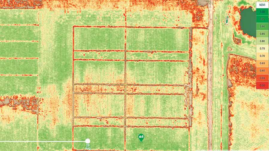
There are a wide variety of applications for drones in agriculture, from basic photographing of fields to highlight problem areas (such as weed infestation and drainage issues), through to detailed crop health analysis that uses near-infrared imaging to produce vegetation index (NDVI) maps.
Such maps aid agronomic decision-making and may allow savings in chemical applications or help increase yields, he says.
The investment required in a drone, camera, sensors and processing software varies significantly depending on the end use, so in some cases Mr Shotton says it may be better to employ a specialist to map fields and process data rather than buy outright.
“Buying a drone can be expensive, so if you’re considering doing so, it’s worth getting a professional mapping company in first.
“It might cost £300-£350 each time or £1,500 over a season, but will answer the important question of whether drone technology works for you before investing in the required training and equipment.”
What sort to buy?
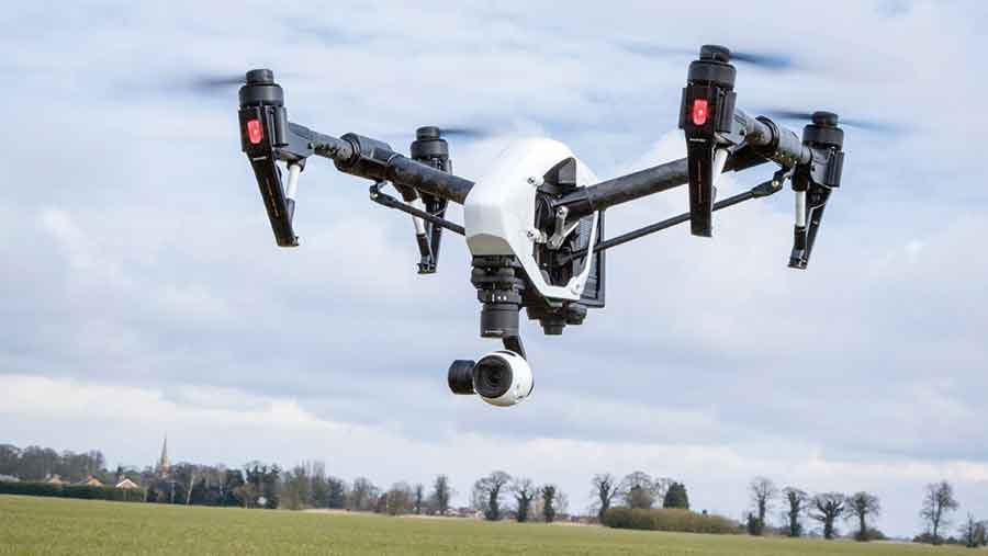
Three main types of drone are available, the most common being multicopters which have four (quadcopters), six (hexacopters) or eight (octacopters) motors.
Quadcopters, such as the DJI Phantom series (costing £400-£1,100 including basic camera) are a popular choice, and will suit many farm applications, notes Mr Shotton.
Six and eight-motor drones tend to be suited to larger loads (up to 20kg total) and are often associated with larger professional cameras.
Other drone types include fixed wing aircraft and hybrids that combine multiple rotors with an aerodynamic wing to increase flying time, says Richard Green from Harper Adams University, who summarises the pros and cons of each.
Pros and cons of the different types of drones
|
|
Pros |
Cons |
|
Multicopter
|
Easy to operate – stable, agile, vertical take-off capability |
Short battery life – typically 10-20 min flight time |
|
Can hover in one place – increases accuracy |
Relatively slow at covering a large area |
|
|
Wide selection to suit different budgets |
|
|
|
Fixed wing
|
Longer flight time – 1-2 hours |
More specialist equipment and software – complex and expensive computer processing required to mosaic images together and analyse to obtain information |
|
Cover larger areas faster |
More expensive |
|
|
Easier to fly |
Requires spotters on the ground to maintain visual contact |
|
|
|
Cannot hover |
|
|
Hybrid
|
Hovering and vertical take-off capability |
Relatively new technology – less choice (patent held by one company) |
|
Longer flight time than standard multirotor (1 hour). |
Currently not commercially available. |
Many drones come with a camera, the most common type being an RGB (visible red, green, blue light) digital camera offering a resolution of 1-3cm per pixel.
Photographs with this level of quality will clearly show patchy crops or weed infestations and data can be used with specialist software to generate 3D topography maps to help with drainage planning. It may also be possible to convert data into some form of basic crop health assessment.
However, RGB cameras do not usually capture the right light spectrum for detailed mapping of crop health, which requires a multispectral camera able to detect infrared, near infrared or thermal images.

Fixed wing drone © Rex/Shutterstock
Costing anything from £3,000 upwards, these are mainly the preserve of commercial operators, but as more multispectral cameras come to market, prices will fall, and uptake by individuals is likely to increase.
Some large farming companies have already invested in their own multispectral camera drones, notes Dr Green.
Many drones only work with certain types of camera, so anyone buying the drone and camera/sensor separately, must check the compatibility of mounts and signal transmission.
Are they easy to fly?
Multirotor drones are relatively easy to fly, even for a novice, so training is not essential, but may be worthwhile to get the best out of the drone and avoid costly mistakes, says Mr Shotton. A one-day course covering rules and basic flying procedures typically costs around £400.
Most drones include a live feed from the camera to a device held by the operator that shows what the drone can see and minimise the risk of hitting objects.
Automatic safety features are increasingly being built into more models, such as anti-avoidance sensors, or automatic return to launch location in the event of signal loss.
Most drones should be operated in dry conditions with a maximum wind speed of 20mph, says Mr Shotton. Although flying in low light is possible, it is not recommended as it reduces image quality.
How is data collected and used?
Systems vary, but generally drone operators can alter flight settings, such as duration, area, altitude and flightpath, which will be controlled by the drone’s in-built GPS receivers and compass.
Camera settings can also be adjusted to change resolution or image overlap – drone mapping works by taking multiple geotagged images that are overlapped (typically by 80%) and then “stitched” together using “mosaicing” software to give a complete high-resolution image of an area.

Example of mapped cornfield using drone technology
Although some drone-mounted cameras can wirelessly transfer data back to the operator in real-time, most store picture data on a memory card in jpeg or tiff format.
Data can then be uploaded to a computer or other device for analysis. Various options are available for data analysis; farmers can buy or rent the software, or upload it to a cloud-based system that converts data into maps or other digital images.
Mr Shotton says farmers should not underestimate the cost of buying software which can be up to several thousand pounds. It is also worth checking whether existing computers and internet connections meet the system requirements before buying.
Rules and regulations
There are strict rules governing the use of drones that all operators should be aware of. Detailed information is available in the Civil Aviation Authority (CAA) guidelines – www.caa.co.uk/droneaware – a summary of which is shown below:
- Stay below 400ft altitude
- Keep drone visible and no more than 500m from operator at all times
- Do not fly within 50m of a person or structure
- Do not fly over motorways, railways, houses
- Do not fly within 150m of a congested area (eg. large gathering of people)
- Do not fly within “Class A” airspace – keep away from aircraft, helicopters, airfields
- Use common sense when flying – failure to fly safely risks prosecution.
Commercial drone operators need to pass a CAA-approved flight course to gain a commercial licence called a Permission for Commercial Operation (PfCO) and have appropriate insurance.
Although these requirements do not apply to private operators, Dr Green says there is a “grey area” around farmers using one on their own land to benefit the farm business.
Many standard insurers will not cover drone use and he advises anyone using a drone to have specialist insurance, covering both third parties and damage to the drone. Some basic flight training may help to demonstrate capability to the insurer, he adds.
Mr Shotton warns that mapping a neighbour’s farm in return for any type of remuneration – monetary or otherwise – is classed as commercial operation, so will require a PfCO and insurance.
It typically costs around £1,100 + VAT for licence training, while commercial insurance cover of £5m third party liability and £15,000 equipment is around £600 a year, he notes.
Jargon buster
- ARF – Almost ready to fly – may require partial assembly or further equipment to fly – check product description carefully
- BNF – Bind and fly – usually come assembled, but without a controller. Check controller compatibility with drone before buying
- Drone – also known as a UAV or unmanned aerial vehicle. A means of carrying some type of aerial camera or sensor
- FPV – First Person View – allows the pilot to see the real-time image from a camera mounted on the drone (often requires a separate camera and transmitter to the recording camera + goggles to view the image)
- Flight controller – computer within the drone that keeps it stable – drones can be setup differently for agility or stability
- Gimbal – a support to keep the camera or sensor level and stable during flight
- Gyroscope – device to help maintain orientation
- Multirotor – refers to any drone with multiple sets of horizontal propellers. Main types are quadcopters (4), hexacopters (6), octocopters (8)
- NDVI – normalised difference vegetation index – map of crop health based on chlorophyll content
- RTF – Ready to fly – usually ready to use, but may require some work such as charging battery, attaching propellers
- Telemetry – data transfer between drone and controller screen such as may display battery power on ground station

