9 steps to obtain accurate combine yield data this harvest
 © Tim Scrivener
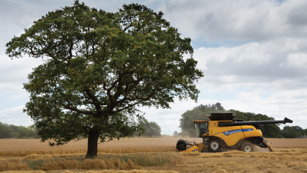
 Combine yield data is increasingly being used to make decisions, but a number of factors can lead to inaccurate maps. Paul Spackman takes a look
Yield mapping has become an essential management tool on many farms, both for evaluating the performance of the current season’s crop, and for highlighting potential problem areas that need addressing before establishing the next one.
See also: North Yorks grower warms to feed winter wheat Beowulf
But to make precise and well-informed decisions based on yield mapping information, the data going into those maps must be as accurate as possible, agronomy firm Hutchinsons says.
“Yield maps are the most valuable bit of data you can get off the field, so they must be accurate,” says Omnia digital services specialist James Lane.
From combine operation to the mapping of field boundaries, many different factors can affect the accuracy of yield data, adds his colleague, Chris Hoskins.
“Individually, each of these factors might have a 2-3% impact on the accuracy of the final data, which seems small, but several issues together can add up to make quite a big difference to the end result.
Here, Mr Hoskins and Mr Lane outline nine steps to maximise the accuracy of yield mapping data this harvest:
1. Map boundaries correctly
Accurate boundaries are fundamental to good quality yield maps, says Mr Hoskins.
“Any spatial data, whether yield maps, satellite imagery, or anything else, will always run to a boundary.
“If the boundary’s the wrong size or shape, everything within that area will be wrong to differing degrees depending on how far out the boundaries are.”
For yield mapping, it is important to identify the boundary of the cropped area and not just the whole field boundary, particularly as many fields have some kind of stewardship margin, which must be excluded from the cropped area, he adds.
2. Exclude in-field features
The same applies to removing any permanent features from the cropped area map, such as pylons, telegraph poles, ponds, or hedgerows extending into fields.
Generally, it is best to make boundary adjustments in the software platform the data is being used in and then export that to the machine, to ensure the two are synchronised, although RTK mapping of actual areas will be preferable to manual adjustment in software.
3. Clean and service yield monitors
Before harvest begins, the combine’s yield monitor should be cleaned and serviced properly to ensure it is in good working order.
This can sometimes get overlooked when servicing other parts of the machine, but it is crucial that measuring equipment is well maintained, Mr Hoskins says.
Also pay attention to any other aspects that may affect the accuracy of yield monitoring equipment, such as the condition of the clean grain elevator.
© Tim Scrivener
4. Understand data aims
Yield mapping data can be used in many ways, from a basic overview of the total tonnage coming off every field, to detailed analysis of in-field variations that will help crop inputs be more precisely targeted.
Being clear about why you are yield mapping, how the data will be used, and what you want to achieve, is essential, and will drive the level of accuracy and fine-tuning required.
As the industry moves towards even greater levels of accuracy, it is worth remembering that the resolution of yield maps is affected by the width of the combine header.
A large machine cutting a 12m swath actually has a lower mapping resolution than a smaller machine making more passes across the field.
In most cases this will not be an issue given the working widths of other operations, but should be taken into account when considering your aims for yield mapping.
5. Ensure accurate combine operation
Combine operators should also be aware of how yield mapping data will be used and understand how certain aspects of combine operation can affect data accuracy.
Procedures for opening up fields, turning at the end of bouts, and cutting swaths less than the full header width are just a few things to consider.
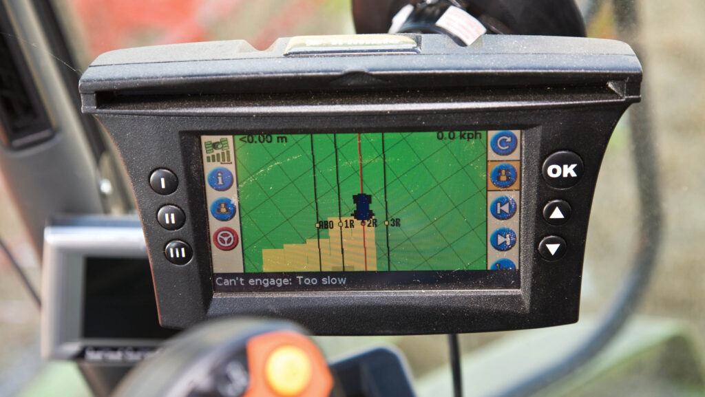
Some older machines, for example, require operators to manually select when a full, half or quarter width is being cut, whereas most modern combines fitted with GPS-linked coverage maps will detect smaller swath widths automatically, explains Mr Lane.
“If you’re only cutting half the width, only half the yield is going in. That’s where anomalies can occur. Generally it comes down to operator education.”
6. Lift the header properly
Similarly, operators should pay attention to the preset “stop height” for the header, which is the point at which the combine stops recording yield data.
If, for example, the stop height is set at 50% raised, the system will start recording yield whenever the header is below that height.
Turning at the end of bouts or other manoeuvres with the header still running and below the stop height means yield is still being recorded and could lead to inaccuracies in the data, says Mr Lane.
The cutting height and optimum stop height is likely to vary for different crops (for example higher in oilseed rape compared with winter wheat), therefore any adjustments must be made where required when moving between crops and fields.
7. Recording bare patches
It may be tempting to lift the header up when passing over bare patches of field, such as those caused by flood or pest damage earlier in the year, but doing so means those areas will not be recorded on the yield map.
Software may then effectively “fill in” those areas on the final map, essentially hiding the points where zero yield would have been recorded.
Where it is safe to do so (such as no deep ruts or very wet patches), it may be worth keeping the header running over bare or thin areas, so they are recorded on the yield maps.
“At the end of the day, those areas have been drilled, with costs incurred, so the fact some crop has failed, for whatever reason, should still be accounted for in the yield maps, especially if you will use the data for cost of production mapping,” says Mr Hoskins.
Alternatively, affected areas can be recorded and geotagged separately before combining, so the boundaries in the mapping system recognise those areas as separate “islands” with nothing in.
8. Calibrate results during harvest
Where growers have access to a weighbridge, then calibrating the combine’s yield monitoring by weighing loads coming off the field and checking moisture content is a very useful way of ensuring mapping data is accurate.
In some cases there may be little or no variation, while in others the figures can be significantly different, says Mr Hoskins.
“The best approach is to follow manufacturer recommendations for regular calibration, but as a rough guide, once per crop is a good starting point.”
Mr Lane adds: “The more you put into setting things up properly, the more accuracy you will get out.”
During harvest, it is also worth going into the field to ground-truth high and low-yielding areas to identify any obvious reasons why that might be the case, particularly if issues need addressing before the next crop.
9. Clean data afterwards
Raw yield mapping data can sometimes contain anomalies and inaccuracies that should be accounted for before producing final yield maps.
These can be due to a number of reasons, such as not cutting full widths, blockages, turning or reversing with mapping still running, or very high or low forward speeds.
Different systems have different ways of cleaning data, so the important thing is to understand what those parameters are, and how clean maps differ from the raw data.
One key aspect to consider is the yield scale, which in Omnia can be easily adjusted to account for different crop types and yield ranges.
“In some other systems, the default yield scales may not be accurate simply because it’s been a very good or bad year for that particular crop,” says Mr Hoskins.
“Field performance can be relative to the year, as well as the crop,” he adds.
Equally, in some crops that produce a comparatively low tonnage at best (such as linseed, poppies, grass seed), it may be necessary to set a bespoke yield scale so variations can be highlighted more clearly on the final maps.